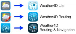
Both historical applications Weather4D (March 2011) and Weather4D Pro (November 2011 ), change to the user interface of Weather4D 2.0 application, which was the subject of a comprehensive review of its development published in December 2015. In order to make more consistent range, the names of the three applications are harmonized :

This change is made only by the way of free updates. The valid weather subscriptions in each application are kept. Finally, three user guides are now to download, for free. They are designed on the same pattern as that of Weather4D (ex. 2.0) French and English.
New in Lite version
General settings
- Adding synchronization with iCloud : used to propagate to other devices areas, settings, places, categories, routes, created on the first device.
Advanced Management of locations by category
- Creating a location (waypoint, POI)
- Creating categories for registered location
- Assignment of location in a category
- Add a name, an icon, display settings
- Zonal attachment, or global (all areas)
- Quick access in Target menu
- Creation/modification entering latitude/longitude coordinates
- individual Change, overall or by category, locations
- Tap on a location opens a context menu creation/modification/deletion
- Tap on an icon opens a context menu creation
Weather
- Extension up to 16 days GFS models
- Adding 0.5° global ARPEGE 4 days
- Adding MFWAM wave models by Meteo-France, 3 resolutions 3 coverages : Global (world), Europe and France
- Adding NCOM current models at 1/30 ° (2 NM) for US and Caribbean coastal region
New in Routing
In addition to the above functions :
- Import waypoints in KML (in addition to GPX)
- Creation of routes by context menu with a tap on a target or location, then by successive taps on registered locations displayed on the map (in addition to the conventional method from a target and then “Begin a route”
- Exporting a routing table .xlsx format, Excel and Numbers compatible spreadsheet
New in Routing & Navigation
In addition to the above functions :
Charting
- Adding a “Update” button on each chart area as soon as a downloaded update has been published by Geogarage, valid for all editors. A tap on the button starts the download of the update by replacing modified tiles.
- Course North Up, COG Up, HDG (compass heading) Up, BTW (bearing to waypoint) Up.
NMEA
- Extension of NMEA output sentences to the appropriate multiplexers and gateways.


